


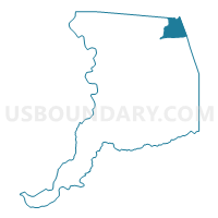
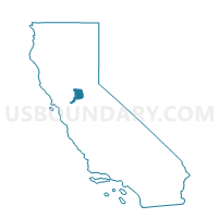
Voting District 40973, Sacramento County, California
About
Outline

Summary
| Unique Area Identifier | 538545 |
| Name | Voting District 40973 |
| County | Sacramento County |
| State | California |
| Area (square miles) | 21.08 |
| Land Area (square miles) | 18.74 |
| Water Area (square miles) | 2.34 |
| % of Land Area | 88.92 |
| % of Water Area | 11.08 |
| Latitude of the Internal Point | 38.67004950 |
| Longtitude of the Internal Point | -121.14468170 |
Maps

Graphs
Select a template below for downloading or customizing gragh for Voting District 40973, Sacramento County, California


Neighbors
Neighoring Voting District (by Name) Neighboring Voting District on the Map
- Voting District 10010, El Dorado County, CA
- Voting District 10025, El Dorado County, CA
- Voting District 40002, Placer County, CA
- Voting District 40065, Placer County, CA
- Voting District 40410, El Dorado County, CA
- Voting District 40976, Sacramento County, CA
- Voting District 40982, Sacramento County, CA
- Voting District 41051, Sacramento County, CA
- Voting District 41054, Sacramento County, CA
- Voting District 41057, Sacramento County, CA
- Voting District 41063, Sacramento County, CA
- Voting District 41120, Sacramento County, CA
- Voting District 41123, Sacramento County, CA
- Voting District 41174, Sacramento County, CA
- Voting District 51234, Sacramento County, CA
- Voting District 51720, Sacramento County, CA
Top 10 Neighboring County Subdivision (by Population) Neighboring County Subdivision on the Map
- Sacramento CCD, Sacramento County, CA (1,072,790)
- Rancho Cordova CCD, Sacramento County, CA (110,868)
- South El Dorado CCD, El Dorado County, CA (102,407)
- Rocklin CCD, Placer County, CA (85,223)
- Folsom CCD, Sacramento County, CA (72,163)
- North El Dorado CCD, El Dorado County, CA (31,207)
Top 10 Neighboring Place (by Population) Neighboring Place on the Map
- Folsom city, CA (72,203)
- El Dorado Hills CDP, CA (42,108)
- Orangevale CDP, CA (33,960)
- Fair Oaks CDP, CA (30,912)
- Granite Bay CDP, CA (20,402)
Top 10 Neighboring Elementary School District (by Population) Neighboring Elementary School District on the Map
- Buckeye Union Elementary School District, CA (36,051)
- Rescue Union Elementary School District, CA (34,326)
- Eureka Union Elementary School District, CA (26,800)
Top 10 Neighboring Secondary School District (by Population) Neighboring Secondary School District on the Map
- Roseville Joint Union High School District, CA (161,902)
- El Dorado Union High School District, CA (136,722)
Top 10 Neighboring Unified School District (by Population) Neighboring Unified School District on the Map
- San Juan Unified School District, CA (321,293)
- Folsom-Cordova Unified School District, CA (122,238)
- Black Oak Mine Unified School District, CA (13,572)
Top 10 Neighboring State Legislative District Lower Chamber (by Population) Neighboring State Legislative District Lower Chamber on the Map
- Assembly District 4, CA (536,793)
- Assembly District 10, CA (508,384)
- Assembly District 5, CA (498,085)
Top 10 Neighboring State Legislative District Upper Chamber (by Population) Neighboring State Legislative District Upper Chamber on the Map
Top 10 Neighboring 111th Congressional District (by Population) Neighboring 111th Congressional District on the Map
Top 10 Neighboring Census Tract (by Population) Neighboring Census Tract on the Map
- Census Tract 206.01, Placer County, CA (6,911)
- Census Tract 85.08, Sacramento County, CA (6,825)
- Census Tract 9883, Sacramento County, CA (6,747)
- Census Tract 85.01, Sacramento County, CA (6,228)
- Census Tract 307.01, El Dorado County, CA (6,205)
- Census Tract 307.06, El Dorado County, CA (6,020)
- Census Tract 206.05, Placer County, CA (5,826)
- Census Tract 84.02, Sacramento County, CA (5,505)
- Census Tract 82.10, Sacramento County, CA (5,472)
- Census Tract 84.03, Sacramento County, CA (5,246)
Top 10 Neighboring 5-Digit ZIP Code Tabulation Area (by Population) Neighboring 5-Digit ZIP Code Tabulation Area on the Map
- 95630, CA (72,180)
- 95670, CA (52,973)
- 95628, CA (40,196)
- 95762, CA (38,797)
- 95662, CA (31,558)
- 95746, CA (21,460)
- 95742, CA (7,749)
- 95664, CA (1,380)